Namnani Peak
Namnani Peak is located in Burang County, the peak is 7,694 meters high. It is 81.3°longitude east, 30.4°latitude north, and is one of the highest peaks in the Himalayas. It is located near Lake Manasarova (Mapam Tso in Tibetan), facing Mt. Kailash, (Gang Rimpoche in Tibetan) in the north across the lake.
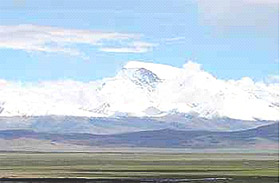 Namnani Peak is called “the mountain of Goddess” in Tibetan. The peak has an area of 200 sq. km and has 6 mountain ridges, on which are tens of mountains soaring to 6,000 meters. The western ridges fan out from north to south. The only ridge in the east has been corroded into a blade-shape ridge, which is very steep with a height difference of 2,000 meters. Compared with the eastern ridge, the western one has a less steep gradient. Five huge glaciers pour down in the canyon, among which are ice steeps full of cracks.
The best to visit
May to late June is the best tourist time for the peak. The weather is fine most of the time, and sometimes, good weather may last for 6 to 8 days.
Transportation
There are two routes stretching to the peak. One is the 3,044 km route from Urumchi, the capital city of Xinjiang, to Burang County. It starts from Urumchi, winds south, joins the Xinjiang-Tibet highway, passes Yecheng (in Xinjiang), Shiquanhe (the capital of Ngari) and finally reaches Burang County. The other is the 1,433 km route from Lhasa to Burang. The route starts from Lhasa, winds west, passes Xigaze, Saga County and finally reaches Burang County.